Geology Notes
The small Earth models shown on this website are based on spherical small Earth models constructed during research into Expansion Tectonics. This research, along with detailed descriptions of model construction methodology and research findings, is summarised elsewhere in this website. Publications available include: "On the Origin of Continents and Oceans" available in both hard cover and eBook format from Amazon.com, and "Terra Non Firma Earth" available in softcover format from James.Maxlow@bigpond.com and in eBook format from Amazon.com.
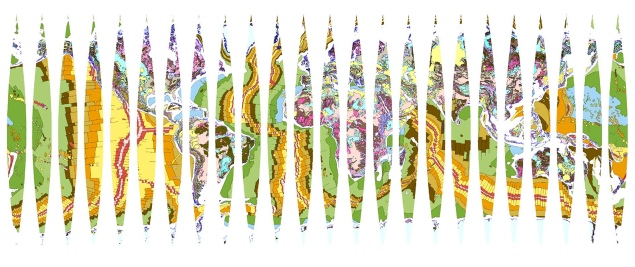
The reconstructed geology shown on each of the small Earth models presented here is based on the "Geological Map of the World", published by the Commission for the Geological Map of the World and UNESCO© (1990). Permission was granted by the Commission de la Carte Geologique du Monda, Paris to use and digitise the Geological Map of the World at 1:25,000,000 M scale for research purposes.
This map is available from www.ccgm.org/en/ and this same map can be downloaded in sinusoidal projection format (see below) at this link. Rescale this sinusoidal map as required and cut and paste directly onto your own spherical model of the present-day Earth.
It should be noted that the continental development of both East and West Antarctica is speculative because of the masking effect of the present-day ice-sheet coverage. This ice cover, as well as the ice-sheet covering Greenland, is part of the Geological Map of the World base map used to construct the small Earth models and could not be removed during model construction. The Antarctic icecap is known to be about 33 million years old, representing a considerable part of the Cenozoic Era. Reconstructions and limited published field evidence indicates that the East Antarctica continent comprises mainly Precambrian crusts and this crust has remained relatively intact throughout Earth history.