

EXPANSION TECTONICS HOMEPAGE
The goal of this website is to introduce you to my spherical scale models of the ancient and present Earth. These models will show the development of ocean basins, continents, and supercontinents, as well as changing distributions of land and sea for the entire history of the Earth.
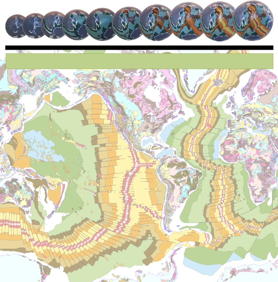
In this website, modern geological mapping of the world is used to reassemble continental and seafloor crustal plates on accurate scale models of the Earth with a precision never before attained. For the first time a series of 24 scale models of the ancient Earth is presented, extending across 4,000 million years of Earth’s recorded geological history, including one model extrapolated to 5 million years into the future.
This research represents the first time that crustal modelling studies of the Earth have been extended back to the early-
The use of modern seafloor and continental geological mapping represents a new way of recreating past plate assemblages of the Earth’s ancient continents and supercontinents. Since the 1960s this global mapping has traditionally been gathered in support of plate tectonic studies and as such, until now, has rarely been looked at other than from a conventional plate tectonic perspective. This conventional perspective is heavily reliant on geophysical studies which insists that the origin of the continents, oceans, and ancient supercontinents is a random, non-
From the small Earth models presented here it is shown that the formation and break-
The spherical models presented here are ideally suited as an alternative conceptual framework for teaching geology. They are fundamentally simple and easy to understand. These models enable you to readily visualise and determine what the geology and geography of the ancient landscape was, as well as understanding the prevailing ancient climate, topography, geography, mineral provenance, fossil provenance, species habitats, and so on, for any moment back or forward in time.
In this website an introduction to small Earth model construction will be followed by discussion on the opening and subsequent development of each of the modern oceans, and followed in turn by the origin and development of the modern continents. Next we will continue in time through the various supercontinental stages where all ancient supercontinents will be shown to remain intact until breakup of the Pangaea supercontinent occurs during the late-
The small Earth models, observations and conclusions presented in this website are based on modern factual evidence which shows that, unbeknown to most scientists today, we may have now reached a critical stage in the development of modern geoscience. One seemingly trivial change in our scientific perspective of the way the Earth’s continents and oceans have evolved has the potential to completely negate many of the established consensus of opinions and scientific beliefs existing today. This, in turn, represents a paradigm shift in our understanding of the evolution of our continents and oceans.
I am a retired geologist who has worked in the field of exploration and mining geology for over 40 years, most recently as a principal geologist for one of the largest gold mining companies in the world. I hold Masters and PhD degrees in geology and have written two books, in addition to my PhD dissertation, on the subject of Expansion Tectonics to which this website is dedicated. The small Earth model reconstructions presented here are based on an extensive modeling and data collation study as put fourth in my PhD dissertation.
My main interest in Expansion Tectonics is driven by the fact that modern geoscientific evidence clearly shows, beyond reasonable doubt, that the concept of an Earth increasing its radius over time far better explains what is empirically observed in geology than conventional plate tectonic theory currently leads us to believe.
Site last updated June 2016
